Indian Topographic Maps
Topographic maps provides the graphical portrayal of objects present on the surface of the earth. These maps provide the preliminary information about a terrain and thus very useful for engineering works. For most part of India, topographic maps are available which are prepared by the Survey of India. To identify a map of a particular area, a map numbering system has been adopted by Survey of India. The system of identification is as follows:
An International Series (within 4° N to 40° N Latitude and 44° E to 124° E Longitude) at the scale of 1: 1,000,000 is being considered as base map. The base map is divided into sections of 4° latitude x 4° longitude and designated from 1 (at the extreme north-west) to 136, covering only land areas and leaving any 4° square if it falls completely in the sea.
 |
| Fig. - Map Numbering System for Indian Topographic Map (4°×4°) |
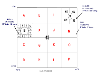
For Indian Topographic maps, each section is further divided into 16 sections (4 rows by 4 columns), each of 1° latitude x 1° longitude (1:250,000), staring from a letter A (North-West corner) and ending on P, column-wise. These degree sheets are designated by a number and an alphabet such as 53 C.
 |
| Fig. - Map Numbering System for Indian Topographic Map (4°×4°) |
These degree sheets are further sub-divided in the following ways:
Each sheet is divided into four parts (2 rows by 2 columns), each of 30' latitude x 30' longitude (1:100,000) designating them by cardinal directions NW, NE, SW, and SE. Such sheets are identified as 53 M/SE.
 |
| Fig. - Map Numbering System for Indian Topographic Map (1°×1°- A Degree Sheet) |
 |
Degree sheets have also been divided into 16 sheets (4 rows by 4 columns), each 15' latitude x 15' longitude (1:50,000) and numbered from 1 (at the north-west corner of the particular degree sheet) to 16 columnwise and are identified as 53 B/3.
Each 1:50,000 scale sheet contains four (2 rows by 2 columns) 1:25,000 sheet ( 7' 1/2 latitude x 7' 1/2 longitude ) which are numbered NW, NE, SW, and SE. Such sheets are identified as 53 O/14/NE.
In this way, the topographic map of most of the area of India may be acqiured at the scale available and subsequently can be updated and upgraded as required for a particular project. For large scale maps, further surveying needs to carried out.
Source : nptel.ac


thnx.
ReplyDelete